Buxton’s coldest night for more than 12 years as air temperature plummets to -8.3°C
and live on Freeview channel 276
The volunteer meteorologists on The Met Office Slopes Weather Station Team, recorded an overnight air temperature of -8.3°C on Thursday January, 18 2024.
Michael Hilton from buxtonweather.co.uk said: “This was the coldest night in Buxton for over 12 years.”
Advertisement
Advertisement
He explained that air temperature, the temperature you see on the weather forecasts, is measured to a worldwide standard - inside a ventilated cabinet on Buxton Slopes known as a Stevensen Screen is about two metres off the ground - at head height.

He said: “Ground level, grass tip temperature is measured by a thermometer on the ground, just touching the grass tips.
“Forecasters refer to this as ground frost is often lower than air temperatures - cold air is more dense so it sinks to the ground and displaces the warmer air upwards.”
He said volunteers Phil Ray and Meg Fowler recorded a grass tip temperature of -12.0°C on the same morning.
Advertisement
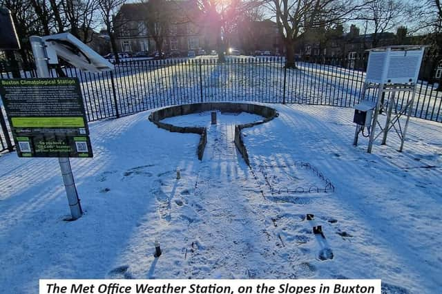
The reading was taken from the Buxton Climatological Station which is one of the longest, continuously recording weather stations in the UK.
Advertisement
The station has unbroken records going back over 150 years, to 1865. The site is the third oldest weather site in the United Kingdom.
Volunteers attend the station each morning, 365 days a year, at 9am to take readings and Michael says more than 20 readings and observations are taken on every visit.
Looking ahead to the beginning of February the Met Office says next week Buxton residents can expect a dry start conditions quickly turning wet and windy into Tuesday, with the potential for strong winds especially in the north.
Advertisement
This will likely clear late Tuesday or into early Wednesday, for a clearer day, especially in the east.
Toward the weekend and into next week the milder than normal conditions seem likely to persist, with a further system likely pushing through the bulk of the UK later in the week.
It is noted however although quite likely milder than of late, the chance of overnight frost and fog increases once again.