Map shows this large area of Derbyshire is almost coronavirus free
and live on Freeview channel 276
And an interactive map shows that a large chunk of the county is now almost entirely free of new cases of the virus.
The map, based on Government data, reveals there were fewer than three cases across Bakewell in the seven days leading up to December 3.
Advertisement
Hide AdAdvertisement
Hide AdThe almost Covid-free swathe includes Baslow and Calver along with the areas of Youlgreave and Taddington.
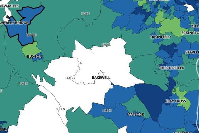

The exact number of positive cases there is not known because data is not given for areas with three or fewer cases to protect individuals' identities.
Ipstones, Warslow and Hamps Valley in the neighbouring county of Staffordshire also recorded fewer than three cases that week.
A small number of people have had allergic reactions to the Covid vaccine - this is what you need to know
Advertisement
Hide AdAnd nearby Buxton North, Harpur Hill, Whaley Bridge and Hathersage all recorded ten or fewer cases.
Advertisement
Hide AdReflecting this, the latest figures show that the infection rate continues to drop across the north of the county.
In the High Peak it fell from 109.0 (or 101 new cases) in the week to November 26 to 84.2 (78 new cases) in the week to December 3.
And in North East Derbyshire it fell from 175.4 (178 new cases) to 104.5 (106 new cases).
Advertisement
Hide AdThe Derbyshire Dales has the lowest infection rate of the local authorities, with 74.7 per 100,000 people (54 new cases). The week before it was 113.4 (82 new cases).
Derbyshire has been placed under Tier 3 restrictions until at least December 16.